|
|
|
THE 7 CLIMBS OF THE COURSE - Geography and topography
Two maps showing the world championship circuit - seen from above and in profile. And at the bottom, a video with both!
On the Google map below, finish line plus the seven biggest climbs are marked. The climbs are given a number according to the order in which they appear on the circuit after the finish line. Click on each of the numbers to get data about height difference, length, slope etc. You will find more information on the page with description and assessment of the climbs.
You can, of course, zoom in on the map and change modes.
Show Race circuit at Rudersdal on a bigger map
Below there is a modified height profile showing the 14 kilometers of the world championship circuit with its seven climbs.
The point of departure is a height profile generated by a Garmin GPS. It matches almost completely the profile that is found on the official site of the championships.
However, GPS profiles can be somewhat unprecise - even with height corrections enabled -, and therefore Danskebjerge.dk has crosschecked it with the help of original topographic maps from the Danish Kort- og Matrikelstyrelse. The adjustments derived from this process are shown as red lines on the modified height profile:
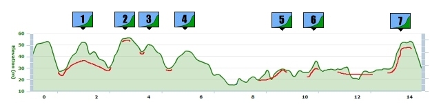
Corrections:
The first inaccuracy of the GPS profile is at Climb 2. The climb is given a size that almost corresponds to Geels Bakke and the "Castle Hill" - while that is far from the case (compare the red line).
At six places the GPS profile has set the bottom of a climb a bit too high. That means that a couple of these climbs are a little bigger in reality, whereas in the case of the others, it is outweighed by the fact that the point of the top has been overestimated a little, too.
Just after kilometer 8 the GPS profile shows a peek that could indicate a climb of around 10 height meters with a sudden descent. This is not the case. There will not be a climb until around kilometer 9 (Climb 5), and it is not a big one.
On Youtube, there is a video that shows the whole 14 kilometer circuit, as seen from a car. Geographic map and (not quite accurate) height profile is inserted graphically:
More data about the climbs here.
Related pages: The course: Analysis (1:2)
|
The course: Analysis (2:2) |
The course: The 7 climbs - description and assessment
|
The course: The 7 climbs - Geography and topography
|
Things to see
|
|
|
|